Translate

Monday, August 18, 2014

The Cliffs of Moher (5/8)

Typical village - brightly painted, small shops,
cars parked facing any direction

Leaving Jeff behind with the dogs and the vans, the rest of us headed off for a walk along the Cliffs of Moher. We stopped off at Lahinch for supplies and a wander. It is a typical Irish village consisting of a series of narrow streets edged on both sides by narrow-fronted shops painted in any colour you can think of. And of course there were several pubs. As always there are several derelict places which probably haven't been touched since the great potato famine.


Looking for Napoleon


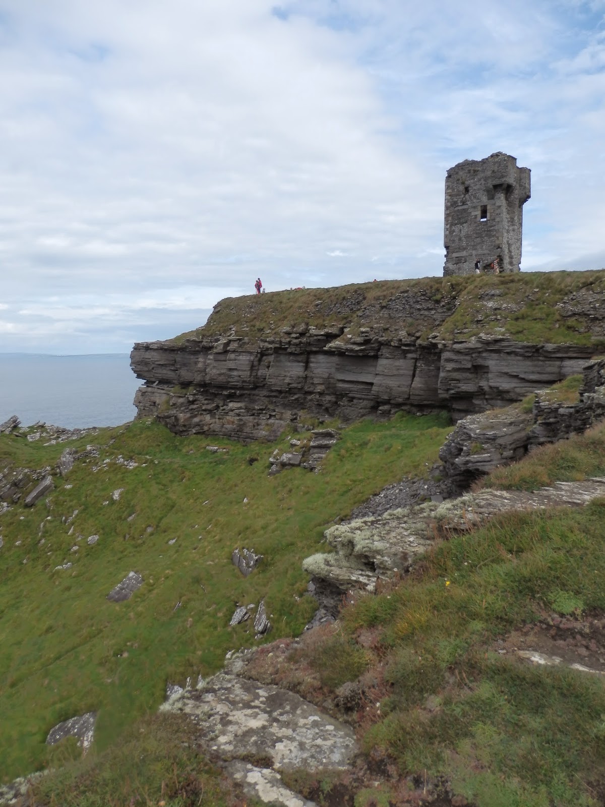
We left Sandie and her crook knee in the car and headed off aiming for a ruined tower on the cliff edge which was built in the Napoleonic era to signal in case of invasion


The view was spectacular, similar to the cliffs on the Great Australian Bight, but not as extensive. We only had a few minutes at the tower as we had a boat trip booked.  We could see where it would take us - the other end of the cliffs - as we could see a couple of the tour boats coming in
Tour boats under the cliffs.  Doolin in the background.
It started to drizzle as we boarded the boat and didn't really let up for much of the trip, but at least it was relatively calm. Ralph was sitting in the wrong position and copped the run-off from the roof of the cabin.  We went along the base of the cliffs and got in quite close them and to a sea stack as well. It was very atmospheric as there was a lot of cloud rolling over the tops of the cliffs.  The cliffs (over 210 metres high) of layers of black shale and sandstone towered above us. There were many seabirds roosting on the cliffs, but we didn't see the puffins which Jill was especially looking out for.
Cloud falling over the cliffs
Sea stack and sea birds


The next morning my run took me out along the cliffs from the camp at sea level so I got a good workout running up the steep path. I passed a tent pitched on one of the headlands – they were very exposed to any weather, but the view was spectacular!
Interesting campsite (running track off to the left - not along the rocks!)

Sunday, August 17, 2014

The Burren (4/8)

Not a bad view on the morning run


I had a good run along the coast from Rosses Point towards Sligo to maintain my goal of running at least every second day. It was a bit fresh, but at least it was dry.


After a communal breakfast, we headed off at our own pace. After several stops for photos, we pulled in to get some petrol and Wendy & Ralph pulled in soon afterwards. We lunched with them and followed them down the road to find a spot to go for a walk in the Burren. We ended up climbing Abbey Hill (240m).

The Burren is a limestone karst landscape scraped bare by glacial erosion, and then eroded to become a patchwork of a stepping stone-like structures called “clints” with eroded cracks being called “grykes”. The Burren covers about 300 sq km and compared to other karst areas is a relatively smooth landscape because of the relatively recent glacial action. (Most other karst areas only show the rock pillars which have not been eroded as would be expected after a very long period of erosion).  As you might expect with limestone country, below the surface is riddled with caves, many of which have never been explored.
Because the general surface of the clints was relatively even, the climb was fairly easy, although some of the smaller rocks were a bit unstable. We rock-hoppers enjoyed ourselves.

Because of the microclimates and geology of the grykes, plant species which are remnants of the ice age have been able to survive alongside plants which are from Mediterranean origin. The variety of flowering plants was huge, although the plants themselves were small, hiding away in the crevices. Those plants that did stick their heads up above the lip of the gryke were either growing prostrate, or had withered tops.


As the weather was clear, the view from the summit was brilliant looking out over Galway Bay with its many inlets, islets and small communities dotted about.
Galway Bay from Abbey Hill
Despite the rocky nature of the ground, fences have been built up to the top of this hill and the one opposite. So much effort for seemingly so little return, but then they were probably associated with the abbey after which the hill was named and the monks built them as part of their penance.  
The mandatory summit "selfie"
After our descent we headed off along the narrow roads to Doolin, one of the ports for ferries going to the Aran Islands.

Friday, August 15, 2014

Bangor to Sligo (3/8)

We travelled independently each day, but with specific rendezvous points chosen – either at a site of special significance or at the proposed camp-site. This meant that each could travel at their own pace. Jeff & Sandie's is a rather large 30ft “bus” which obviously had to stick to the larger roads, whereas Wendy & Ralph's more modest vehicle was able to tackle the narrower roads. Both were slower than our vehicle.  Travelling like this meant that we could each stop or detour where we wanted, however it was interesting the number of times we came across each other between planned stops.


Castle Coole
Our first planned stop was at Castle Coole, a National Trust property near Enniskillen.  It was a convenient distance along our planned route to have a break, and we caught up with Wendy & Ralph (who had left earlier than us) just before the turn off.
The "castle" is a large house built in the very severe "neo-classical Georgian" style (if you know what that means" designed by James Wyatt and commenced in 1789 for the Earl of Belmore.  There is no back door to the building at ground level.  All the deliveries and the servants entrance was via a long tunnel lined with store areas leading from near the stable area.
Wyatt was a pedant for symmetry, and throughout the rooms where there is a door, there is another directly opposite (or at least a false door).  

As was expected of people of their status in those days, a room was set aside for the king should he visit, but the planned visit never eventuated and so this room was decorated with a number of Hogarth's satirical cartoons poking fun at the aristocracy and in particular royalty.  I guess the family were allowing these to express their opinions.  Apparently the only person to ever use the room was an archbishop.

When the place was sold to the National Trust (to pay for death duties), all the furniture, a lot of which was Regency style, went with it and is considered reasonably rare.

The National Trust is working on restoring the servants quarters and the service areas which are probably the more interesting parts of the building as they were critical to the functioning of the formal life, but were kept very much out of sight.

The Australian connection with the place is that the 4th Earl Belmore was Governor of New South Wales 1868-1872 and there is a suburb in Sydney named after him.

At some stage we crossed over the border into Ireland, but we didn't see any signs to say where the border was.  We suspect we were looking elsewhere.  We just noticed that suddenly the speed signs were in kilometres rather than miles, and that the markings along the edge of the road were in yellow rather than white.  No border control, no passport check, no customs, nothing!!


The campsite and view.
The team consist of the brown "bus", the car to the right of it
and the camper immediately to the right
of the VW in the foreground
The trip down to Rosses Point (just past Sligo) to a campsite our friends have used before was along green valleys, past waterfalls (fed by the heavy rain showers we experienced.  The last part in particular was down narrow roads with trees overhanging so much they formed a complete arch.


May be difficult to see but a person is swimming
at the other end of the beach!
(The 3 girls & the dogs in the foreground)
The campsite was the antithesis of those we normally prefer.  It had no shade at all (not a problem in this weather) but a great view out across the water.  


Despite the weather, there were a couple of people in swimming - the Irish must be desperate!

Thursday, August 14, 2014

Ireland - Giant's Causeway (2/8)

We are to spend just over a week exploring Ireland with friends (Sandie & Jeff - and their miniature schnauzers - and Wendy & Ralph) from Allan's university days in London.  We will be using their motor homes and our hire car to get around.
Everyone over here has been telling us what a good summer they have had, but for our first day in Ireland it absolutely poured!  Despite that we headed for the Giant's Causeway hoping for a break in the weather.
The area is not as big as expected, but the basalt is obviously a lot tougher than that at the Organ Pipes near Melbourne as they have to withstand the nasty weather.
Despite the rain, and because we had come all that way, we went and had a look - and got soaked for our efforts.  It took a few days for our shoes to dry out.
Heading down to the area - the black rocks just beyond
the figures on the path

As you might expect, there were many tourists
at the site - despite the weather

The height here is about the same as the
Organ Pipes near Melbourne


Three of the drowned rats!

Wednesday, August 13, 2014

Old & New Technology


In England and Ireland in our first couple of days we have been interested in some of the technology we have seen, so I'll share a couple that we have managed to photograph.


The first we saw in Chester.  It was one of the aircraft modified to carry parts of the airbus A380 between the various manufacturing sites.  It looks like a huge beluga whale.  This one was photographed through the windscreen of the car as we were driving along and as you can see, we have power lines through the middle of it.  We almost missed it.


As we were driving in Northern Ireland we were held up behind this guy riding along on his bike while pushing a motor mower.  He wasn't particularly successful at it as he fell off a number of times.  We deliberately stayed behind him until we could get this photograph.  Throughout our trip in Ireland, the traffic was held up by cyclists, even on main roads.  The roads are so narrow that it is impossible to get off to the side, so you just have to wait.  Of course there were cycle races (rain, hail or shine) which held us up as well.

Ireland is known for its horse racing, and there are racecourses everywhere.  I think I only noticed one trotting track, but of course you have to exercise the horses somewhere, so why not along the road to the pub!


The Irish fishing fleet is not nearly as large as it used to be, but there are still a lot of fishing boats around.  They need to be pretty tough to put up with the weather in the Irish sea.


We saw this strange looking contraption off Portaferry (N.I.) at the entrance to Strangford Lough.  It wasn't being used at the time, so you can see the workings.  It is a tidal-powered electricity generator. As you might be able to see, it has two propellors on the end of each of its arms which are lowered into the tidal race between the sea and the Lough.  For the technically minded it is a twin rotor 1.2MW SeaGen and it generates 10MWh of energy.  It was installed in 2008.  For more information (and a clearer picture) see http://www.seageneration.co.uk.  At least one other tidal generator is being trialled here as well. http://en.wikipedia.org/wiki/Evopod

Chester Cathedral

The blog has been slow in coming as web access has not been easy and we have been working through emails in preference.  There should be more regular updates from now on.

When we first arrived in the UK our friend Christine took us to visit Chester cathedral.  They have very recently opened a tour to its tower so we thought we would see what it was all about.
Chester Cathedral with flower garden
commemorating the Cheshire Regiment
and showing the tower.

The cathedral itself has quite an interesting history. There are records of a Christian church being built on the site of a Roman temple, and the church had been in existence well before 660. A monastery was founded on the site about 975AD which was then converted to a Benedictine monastery by Hugh Lupus a nephew of William the Conqueror in 1092. Some of the Romanesque style building from that era can still be seen in the current structure. Henry Lupus was a tyrant and fathered many illegitimate children, but late in life became a monk (perhaps to atone for his sins!!). The building of the monastery began at the east end in 1092, working from east to west; the style of the church was Romanesque, in imitation of the Roman building style, with round headed arches and solid masonry. Once the greater part of the east end was finished and could be consecrated to allow services to take place, the work began on the cloisters (the domestic buildings) while building continued on the church.

Interior looking towards the west window
The last part of the domestic buildings to be constructed was the Chapter House in about 1250 and by that time, the architectural style had changed to the Gothic, with its pointed arches and ribbed ceilings.
However, the church in the Romanesque style then looked very old fashioned and so the monks decided to rebuild their church in the more up to date Gothic style. Rebuilding began in about 1260 at the east end with the construction of the Lady Chapel.
Work continued with the remodelling of the quire in 1290. The Crossing followed in about 1300, followed by the south transept in 1350. The south side of the nave was remodelled in 1360 but the north side of the Nave was not built until 1490 – this 130 year break in building was due to the Black Death when not enough workers were on hand to continue the building.
The west end was constructed about 1515/20 and the work then moved aloft to construct the upper windows and the stone ceilings. However, the monastery was dissolved in 1539; building ceased at that time and very plain wooden ceilings were erected to allow services to take place inside.
Unusually, however, Henry VIII handed the monastery back as the Cathedral of the newly created Diocese of Chester (Church of England), so the building was preserved. the last Abbot became the first Dean of the Cathedral while the senior monks became the first Canons. By the nineteenth century, it was clear that the building needed restoration and some work was undertaken in the 1830s. However the major restoration took place 1868- 76. The cathedral and former monastic buildings were extensively restored during the 19th century (amidst some controversy). As the tower was raised, the bells were shifted higher, but the vibrations started to cause problems with the structure such that in 1975 the bells were shifted to a free-standing tower, the first such arrangement in England.
The cloisters


A lot of the monastic structure is still in existence today, and much is still in use. The Chapter House was built in about 1270, and all the abbots and earls of Chester are buried here. The cloister is enclosed, unusually, by windows (of stained glass). We don't know whether these were an improvement as part of the 20th century works or whether glass was used prior to that. One nice touch is that the former monastic refectory is now being used as a cafe/restaurant with lots of home-made cakes and biscuits of great quality on sale.
For the climbers - here is a dedication
to Mallory & Irvine who disappeared
on Everest in 1924

As mentioned, the Cathedral has recently added a tour of the tower to the tours they run. Being recently accredited, it has passed all the OHS requirements, which means that some parts of the tower are still out of bounds to the public as they are not considered safe enough. The tour took us up the very steep and narrow winding stairs used by the maintenance staff and the bell-ringers. We were able to get a closer look at the
One of the bells still
in the tower.
Roman arches, the huge organ (with over 4,000) pipes, some of the very fine stained glass, and views of the cathedral from the gallery. Heading up the tower we saw the various levels from which the bell-ringers worked over the years – at one level because church officials wanted to be able to see the fine roof, they had to work from a gallery such that if they lost control they could be flung down into the church many metres below (but there is no record of this happening). The tower is finished off with turrets rather than a spire, although that was the original intention. Politics decreed that the spire should not be higher than the town hall, and as the turrets were already at that height, it was never built giving the cathedral its unique outline.

The tower is quite a good lookout and you can see Wales and 5 counties from it. Charles I used it to watch the battle of Rowton Heath which he lost leading to him losing his head a year later.

The tower visit is worthwhile, but not for the claustrophobic or those who suffer from vertigo.

If anyone is interested, the following links have a lot more detail about both the cathedral and the tower:  http://en.wikipedia.org/wiki/Chester_Cathedral
http://www.chesterwalls.info/cathedral.html

Saturday, August 2, 2014

Abu Dhabi

Abu Dhabi is very much a work in progress, and being in the desert there is dust everywhere.  The airport is huge, however, but the passenger management leaves a lot to be desired.
The Control Tower looms out of the dust